


Research Fields
Here you can learn more about the research areas you can find at our chair. These build on the expertise that the team has accumulated over the past 10+ years.
Research Focus Areas
- Flood Forecasting and Early Warning Systems
- Risk-Resilience and Cascading effects of critical infrastructure and health
- Numerical Modelling
- Design of Hydraulic Structures
- Hydraulic model experiments
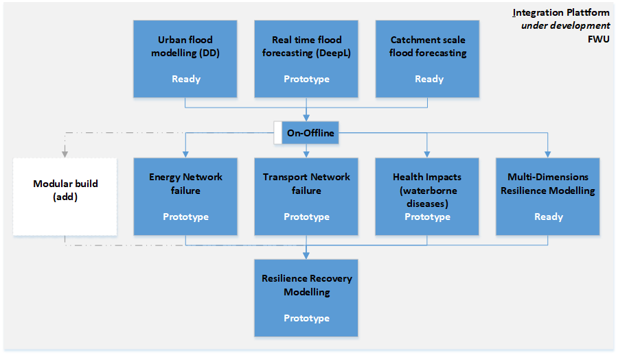
The development of an Integration Platform is the overarching goal of our research.
Flood Forecasting and Early Warning Systems
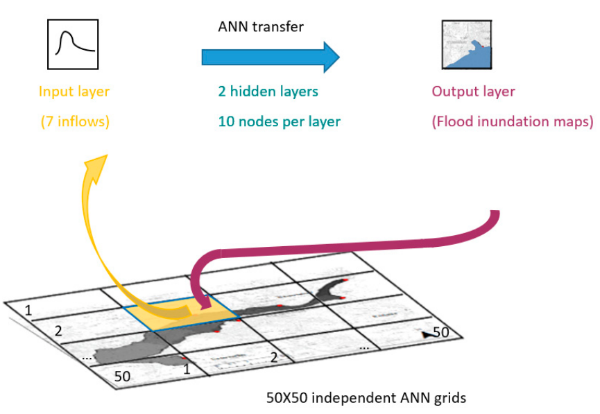 ANN - 2D FORECAST | Herein we have developed a tool for performing 2D multistep forecasts triggered by a forecast threshold value. An ANN with a high spatial resolution (4 m × 4 m) is developed applying Resilient Backpropagation to allow for multiple forecasts covering an area of area of 12 km2. Forecasts up to 5 hours lead time are issued in a matter of seconds. Read more: https://www.mdpi.com/2073-4441/12/12/3568 https://www.frontiersin.org/articles/10.3389/feart.2020.00332/full |
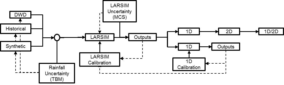 FLOODEVAC TOOL | A major advance was the ability to produce flood forecasts considering a chain of uncertainties, from rainfall to runoff and to the 2D flood inundation maps: The FloodEvac tool is coded in Matlab to facilitate transferability. The tool was tested and validated in upper river Main with a total area of 4000 km2. Read more: https://www.mdpi.com/2076-3263/8/9/346 |
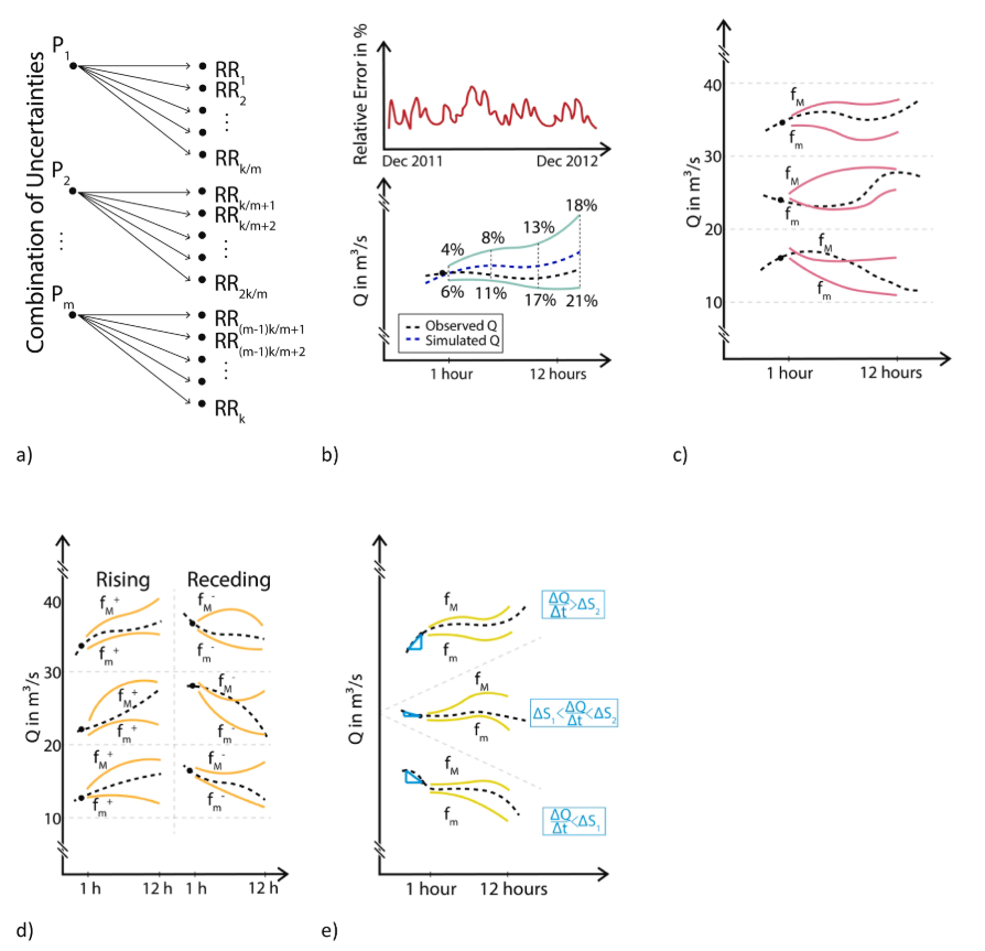 UNCERTAINTY | River discharges flood forecasting is a complex task with multiple sources of uncertainty. To reduce the uncertainty in the forecasts, we focus solely on the prediction of the upper and lower range of the uncertainty bands. Herein we develop three forecast methods in which we search for the indexes of the upper and lower forecast members of an ensemble (termed best-pairs), which provide the highest predictive skill. The novel approaches are implemented in the Flood Evac Tool. Read more: https://www.sciencedirect.com/science/article/abs/pii/S0022169419305992 |
Risk-Resilience and Cascading Effects of critical infrastructure and health
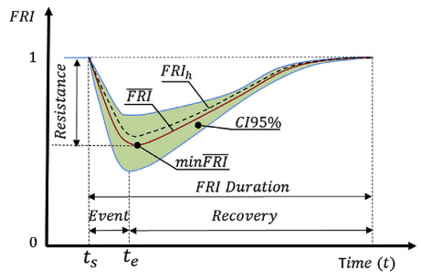
| SCALABLE FLOOD-RESILIENCE-INDEX | Climate change is affecting the frequency and intensity of rainfall extreme events worldwide. Despite the growing global awareness, developing flood resilient cities has proven to be a major challenge. Here we investigate and develop an event-based scalable Flood Resilience Index (FRI) for assessing climate change adaptation. Flood resilience is represented by three dimensions: physical, social and economic. The FRI can successfully identify house- holds and districts which: a) are mostly affected by heavy rainfall, b) benefit the most from the climate adaptation, and c) are the most resilient. Read more: |
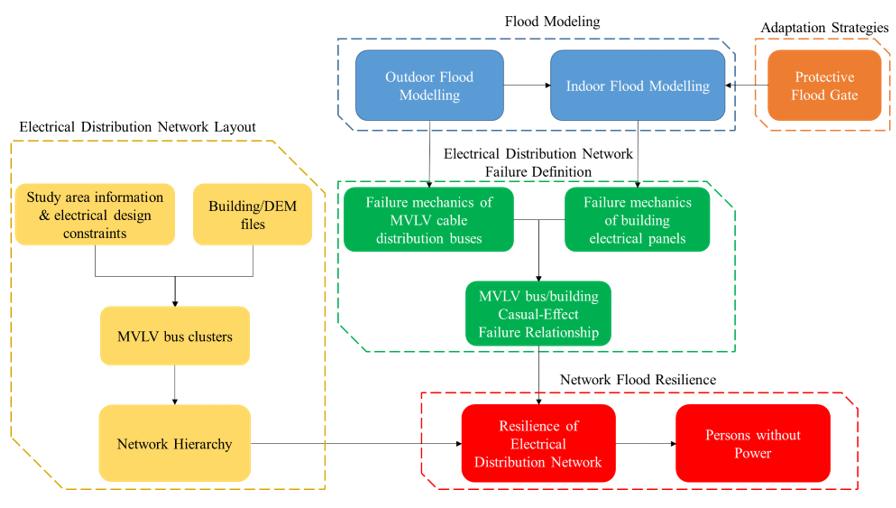
| ELECTRICAL NETWORK FLOOD RESILIENCE MODEL | Of many defining characteristics for a flood resilient city and its infrastructure networks, mitigating flooding impacts and recovering quickly to a pre-flood state are to be considered of high importance. Here an Electrical Network Flood Resilience Model was developed for assessing the timing and location of network components failure due to flooding and number of affected persons without power. Read more: https://www.frontiersin.org/articles/10.3389/feart.2021.572925/full |
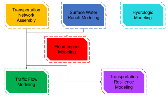
| TRANSPORT NETWORK FLOOD RESILIENCE MODEL | A flood resilient transportation network is defined by its ability to resist the impact of a flooding event, to maintain mobility throughout the event, and to restore functionality quickly and effectively. Herein we develop a methodology to quantify a transportation network flood resilience metricand apply it to the study area of Accra, Ghana Read more: to be submitted. |
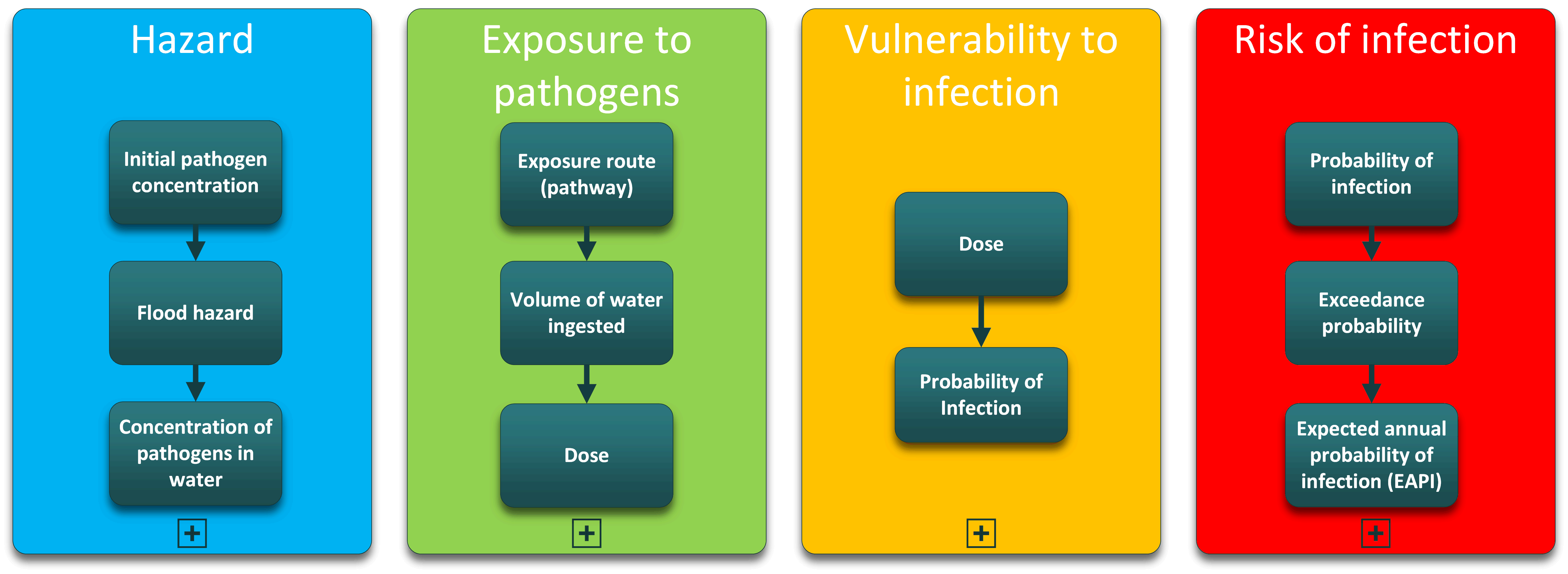
WATERBORNE INFECTIOUS DISEASES | Waterborne diseases continuous to take a heavy toll on global health community. Particularly young children in developing nations carry most of the burden. This prototype developed at FWU applies a new approach for the investigation of waterborne infections after an accidental ingestion of contaminated floodwater. The concept of Expected Annual Probability of Infection (EAPI) is implemented in an infection risk-model approach, by combining a Quantitative Microbial Risk Assessment (QMRA) with the four steps in flood risk assessment. The concept of EAPI was demonstrated for cholera but it can be extended to other waterborne diseases and also different pathways of exposure, requiring minimal adaptations. Read more: https://www.sciencedirect.com/science/article/abs/pii/S0043135422005140?via%3Dihub |
Numerical Modelling
 2D P-DWAVE | Overland flow in urban areas, it is a typical example of open channel flow. These can be efficiently simulated with a simplified form of the shallow water equations (SWE). Here we developed a fully mass conservative finite volume scheme by introducing a constrain variable psi, directly in the fluxes. Instead of solving the full SWE herein a parallel diffusive wave model (P-DWave) is implemented with beneficial stability and computational efficiency. Read more: https://www.sciencedirect.com/science/article/abs/pii/S0022169414003849 |
 2D P-DWAVE 1D SWMM | When focusing on urban drainage system, we need to accommodate the possibly of transition between pressurized and open channel flow. The Storm Water Management Models (SWMM) implements the Preissmann slot. This is a slot placed atop the pipe, which allows seamless transition between the wo, while keep the equations for open channel flow. To facilitate the seamless communication between the SWMM and P-DWave dynamic link libraries are developed to create an efficient Dual-Drainage (DD) model. |
 URBAN HYDR | In Urban areas we recognize that it is not enough to only consider the dual-drainage system. Herein we added to urban key features to the DD Model: I) and physical based infiltration model, as a function of open street maps, and II) a conceptual rainfall-runoff model for buildings. In the former we consider the hypotheses that due to the trampling of man and machinery, soils increase their compacity, and therefore the field capacity is artificially reduced. The latter can be easily adapted to different types of buildings and roof connections to the drainage system. A truly urban flood model. Read more: https://www.sciencedirect.com/science/article/abs/pii/S0022169416000780 https://www.sciencedirect.com/science/article/abs/pii/S0022169421001840 |
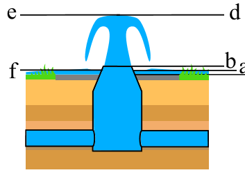
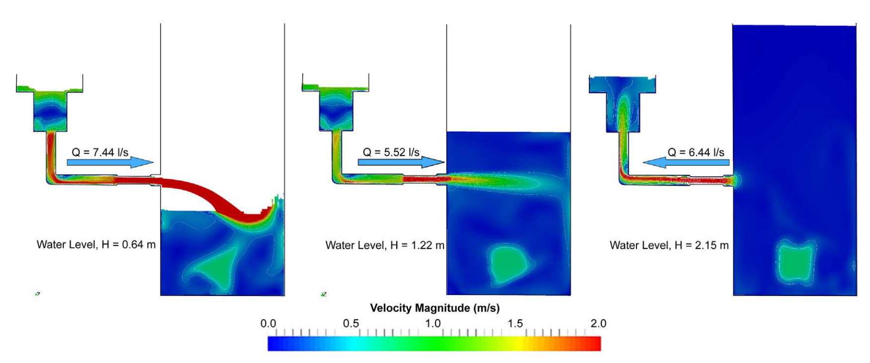 3D MODELL | In an urban drainage system, surface system and buried system are connected through several linking elements like gullies and manholes. Herein the solver interFoam with VOF capability under open source CFD toolbox OpenFOAM® is used for studying the effects on inline manhole head loss coefficient and gully flow due to change in manhole surcharges. Read more: https://www.sciencedirect.com/science/article/abs/pii/S1570644316303914 |
Design of Hydraulic Structures
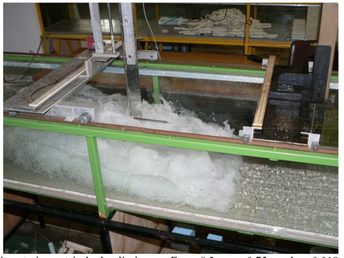 HYDRAULIC JUMP | Hydraulic jump is a sudden transition from supercritical to sub-critical flow. It is associated with energy losses. It is highly turbulent flow with high Reynolds numbers. The entrainment of air occurs in the recirculation zone. Untils this publication air-concentration was being measure via punctually with a probe. The breakthrough idea herein was to enable instantaneous measurement of spatial air concentration through the development of non-intrusive flow visualization techniques: The Image Processing Procedure (IPP). Read more: https://link.springer.com/article/10.1007/s00348-011-1257-1 |
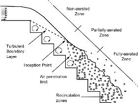 STEPPED SPILLWAY | Stepped spillways have higher energy dissipation than smoother hydraulic structures used to divert flood discharges. For large discharge rates and for straight stepped spillways, the skimming flow regime may be assumed two dimensional; this is an attractive feature for the application of non-intrusive flow visualization techniques (IPP and BIV). Read more: https://link.springer.com/article/10.1007/s00348-014-1732-6 |
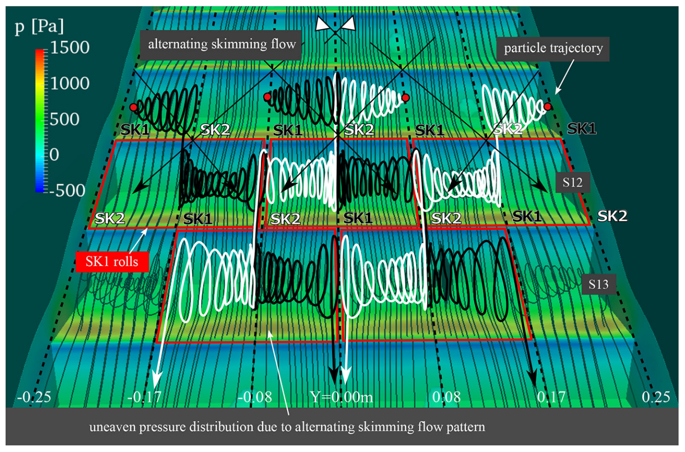 ALTERNATING SKIMMING | The study of stepped spillways in laboratory scales has been essentially focused on two separated sub-regimes within skimming flow. In this paper we investigate the appearance of an unclassified alternating skimming flow regime in a 0.5 m wide stepped spillway which does not fit on these earlier definitions, and which does not occur in a 0.3 m wide spillway. Herein we use 3D numerical modelling techniques to explain the genesis of this unclassified flow which is visualised in the physical stepped spillway. Read more: https://link.springer.com/content/pdf/10.1007/s10652-016-9484-x.pdf |
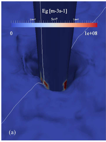 AIR ENTRAINMENT | The accurate prediction of self-aerated flow is not always easy to obtain, particularly if the computational performance is the main concern. Two-fluid formulation is suitable to simulate the dispersed air in a continuous water phase (e.g. bubbly flows) in a fine mesh, whereas the interface tracking methods are used for sharp interfaces with two continuous and contiguous phases (e.g. free-surface flows). Several approaches have emerged to combine both methods; however all found a gap in the transition between resolved and unresolved scales of air at the interface. Including a source term that predicts the self-aeration process is viewed as a promising step to overcome such difficulty. Herein we added to the volume-of-fluid formulation an extra advection- diffusion equation connected to a source of air at the free surface to simulate the dispersed bubble phase. The free-surface given by the air-entrainment model is in good agreement in both non-aerated and aerated zone of the spillway. Read more: https://www.degruyter.com/document/doi/10.1515/ijnsns-2017-0015/html |
Hydraulic model experiments
The construction and operation of physical model tests is still a suitable method for optimizing hydraulic structures, which (due to their complexity and internal interactions) cannot computed directly (or only with uneconomical high effort). As examples out of many projects, models for the redesign of the Sieg in the Siegen city center (scale 1:30) and for a new bridge in the Osnabrück city center (scale 1:16) were carried out. These models are often required to define boundary conditions for detailed 2D or 3D calculations (“hybrid models”). In case of safety-relevant components e.g. of reservoir dams, the approving authority often requires a hydraulic model test on a "large scale". Therefor a full model, with all main hydraulic components, of the Malter dam (in Saxony in the east of Germany) was successfully built for the extension of the flood relief system on a scale of 1:25 (examples see Pictures below).
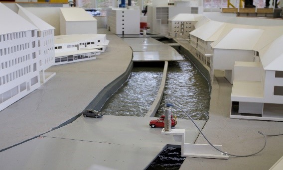 | 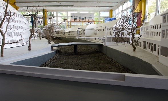 |
A-B comparison (“before vs after”) to identify the water level and flow velocity changes in the river section of the river Sieg in the inner city of Siegen (scale 1:30). Option A (left picture): Parking lot structure with 38 support concrete pillars in the river. Riverbed with a smooth sole pavement. Option B (right picture): Natural remodeling with a rough sole.
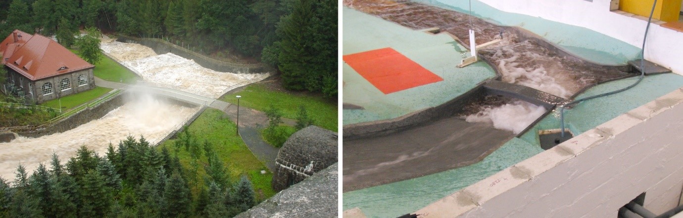
Left picture: the real flood relief of the Malter reservoir with about 185 m³ / s
Right picture: similar flow conditions in the 1:30 model scale
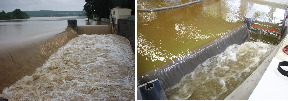
Left picture: discharge of approximately 185 m³/s in the relief channel (view against flow direction)
Right picture: similar situation in the model scale of 1:30